Maps and Scale Drawings FSQ1
Consider the map of Africa below.

Maps and Scale Drawings FS1(a)
Calculate the distance in miles from Khartoum to Dakar.
Answer type: simple
Answer: 2750 miles
Workings:
2 squares is 1000 miles so 1 square is 500 miles
The distance on the map from Khartoum to Dakar is 5.5 squares so the distance in miles is:
5.5\times500=2750 miles
Maps and Scale Drawings FS1(b)
Calculate the distance in miles from Khartoum to Durban.
Answer type: simple
Answer: 3000 miles
Workings:
The distance on the map from Khartoum to Durban is 6 squares so the distance in miles is:
6\times500=3000 miles
Maps and Scale Drawings FS1(c)
How many times further away from Cairo is Durban than Khartoum?
Give your answer to 1 decimal place.
Answer type: simple
Answer: 3.5
Workings:
Khartoum is 2 squares from Cairo which is a distance of 1000 miles
Durban is 7 squares away from Cairo which is a distance of 3500 miles.
So Durban is \dfrac{3500}{1000}=3.5 times further away from Cairo.
Maps and Scale Drawings FSQ2
The diagram below is a scale drawing of the side view of a warehouse.

Calculate the height of the warehouse using the scale provided.
Give your answer to the nearest metre.
Answer type: simple
Answer: 12 m
Workings:
The warehouse is 5 squares tall on the diagram.
Using the scale, 1 square is 2.3 m, so the actual height of the warehouse is:
5\times2.3 = 11.7 m, which is 12 m to the nearest metre.
2 marks
Maps and Scale Drawings FSQ3
An architect designs a building with the following ground floor plan.

Calculate the area of the ground floor.
Answer type: simple
Answer: 104 m^2
Workings:
Dividing the ground floor into four compartments makes it easier to calculate the area.

The area of triangle A is \dfrac{1}{2}\times4\times4=8 m^2
The are of rectangle B is 4\times6 = 24 m^2
The area of rectangle C is 4\times10 = 40 m^2
The area of rectangle D is 4\times8=32 m^2
So the total area is 8+24+40+32 m^2
4 marks
Maps and Scale Drawings FSQ4
Below is a map of Europe with some cities marked.

Maps and Scale Drawings FS4(a)
Calculate the distance in miles from Lisbon to Athens.
Answer type: simple
Answer: 875 miles
Workings:
2 squares is 350 miles so 1 square is 175 miles
The distance on the map from Lisbon to Athens is 5 squares so the distance in miles is:
5\times=175=875 miles
1 mark
Maps and Scale Drawings FS4(b)
Calculate the distance in miles from Birmingham to Malaga.
Give your answer to 1 decimal place.
Answer type: simple
Answer: 612.5 miles
Workings:
2 squares is 350 miles so 1 square is 175 miles
The distance on the map from Birmingham to Malaga is 3.5 squares so the distance in miles is:
3.5\times=175=612.5 miles
1 mark
Maps and Scale Drawings FSQ5
Robson is a fisherman.
He catches a large fish and decides to draw a scale diagram.

Maps and Scale Drawings FS5(a)
Calculate the length of the fish using the scale diagram.
Answer type: simple
Answer: 1.2 m
Workings:
The fish is 8 squares long and 2 squares is 0.3 m
The length of the fish is therefore \dfrac{8}{2}\times0.3=1.2 m
1 mark
Maps and Scale Drawings FS5(b)
Robson’s friend, Jerome is also a fisherman.
He catches a fish that is 0.8 m long.
Calculate the scale of the following 1 cm grid diagram.

Answer type: simple
Answer: 1 cm square = 0.16 m
Workings:
The fish is 5 squares long, and this is equivalent to 0.8 m
So 1 cm on the grid is equivalent to 0.8\div5=0.16 cm
1 mark
Maps and Scale Drawings FSQ6
Which of the following diagrams is a 1:5 scale drawing of a rectangle with side lengths of 20 cm and 37.5 cm
Answer type: multiple choice
Answer:
WRONG ANSWERS:
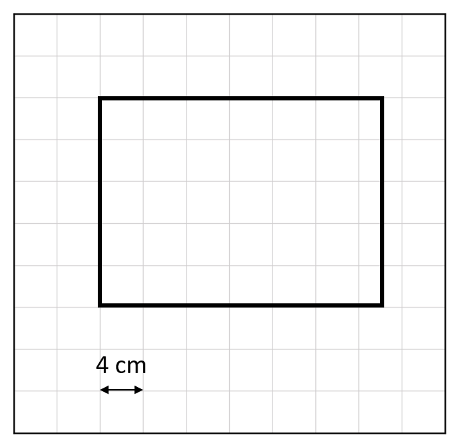


Workings:
The correct diagram has sides in the ratio 37.5:20 which simplifies to 7.5:4
This is equal to the dimensions (in squares) on the correct diagram, using a scale of 1 square =5 cm